

In the last week of August 2026, smoke from fires in Kalimantan drifted across Indonesia’s borders into Malaysia, Singapore and Brunei. In the Himalayas, a glacier-related slope failure sent floodwater and debris downstream across the Nepal-China border. Neither event stayed neatly within the country where it began.
Kalimantan Is Burning Again
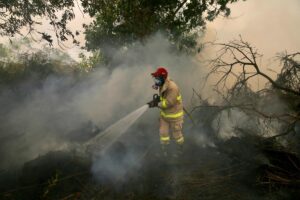
Indonesia is at the centre of Southeast Asia’s current haze crisis, as an extreme dry season and El Niño conditions intensify forest and land fires. Indonesia’s Forestry Ministry reported that more than 202,000 hectares had burned between January and July 2026, with West, Central and South Kalimantan among the areas facing the highest fire activity.
It would be a mistake, though, to treat El Niño as the whole story. Fires do not start in a vacuum. Extreme dryness becomes more dangerous when it meets a landscape already altered by decades of land conversion, including industrial pulpwood and oil palm expansion and the drainage of peatlands. El Niño creates the conditions for extreme dryness; land-use change can make the landscape more vulnerable when those conditions arrive.
The consequences do not stay inside Indonesia’s borders. Malaysia’s Bernama news agency reported that smoke pollutants from fires in Sumatra and Kalimantan were moving toward Malaysia, Singapore and Brunei, while parts of Kalimantan recorded hazardous air quality.
A Regional Agreement With a Persistent Gap
ASEAN has had a regional mechanism for addressing transboundary haze for more than two decades, and Indonesia is a party to the ASEAN Agreement on Transboundary Haze Pollution. The problem is not the absence of an agreement. It is the gap between regional commitments and what can be monitored, enforced and sustained on the ground, particularly when it comes to land management, corporate accountability and cross-border information sharing.
That gap matters because haze does not follow national jurisdiction. Malaysia can raise the issue diplomatically, but much of the underlying enforcement still depends on what Indonesia can do within its own territory. The result is a recurring regional problem whose consequences are shared across borders while much of the response remains national.
Nepal’s Disaster Came From the Same Logic
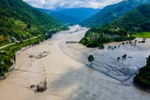
On August 26, 2026, a catastrophic debris flow and flood struck near the Nepal-China border after a rapid slope failure involving a glacier in Nepal’s Langtang region. The debris travelled nearly 100 kilometres through the Lende Khola and Trishuli Khola river systems, damaging settlements and infrastructure downstream, including the Rasuwagadhi border post. The U.S. Geological Survey said it remained unclear whether the initial failure was a landslide incorporating part of a glacier or a glacial collapse.
The seismic signal generated by the event was equivalent to a magnitude 5.2 earthquake, but the USGS determined that it came from the slope failure itself rather than a separate tectonic earthquake. The disaster has since killed more than 1,000 people in Nepal and left thousands missing, while China has reported additional deaths and missing people in Tibet.
What can responsibly be said about climate change’s role is narrower than some headlines suggest. Scientists still need detailed, site-specific research to determine the precise causes of this particular collapse. The broader climate signal, however, is clear. ICIMOD reported in 2026 that glacier ice-loss rates across the Hindu Kush Himalaya have doubled since 2000, increasing risks associated with changing water systems and mountain hazards.
The distinction matters. Climate change is altering the conditions in which these hazards occur, but that does not mean every individual collapse can automatically be attributed to climate change.
Existing Channels, Uncertain Sufficiency
Nepal and China are not starting from zero on cross-border risk. Regional scientific institutions such as the International Centre for Integrated Mountain Development monitor hazards across the Hindu Kush Himalaya, while Kathmandu and Beijing have existing channels for cooperation on border, water and disaster-related issues.
The more difficult question is whether those arrangements are sufficient for risks that can move across borders within minutes. Early warnings, hazard mapping and real-time information sharing become particularly important when an event begins in a remote mountain environment but threatens communities and infrastructure downstream.
Unlike the ASEAN haze framework, there is no comparable dedicated regional mechanism specifically focused on cross-border glacier and landslide emergencies. That does not mean cooperation is absent. It means the region’s existing systems may face a growing test as mountain hazards become more difficult to anticipate and manage.
The Pattern Underneath Both Disasters
Kalimantan and Nepal are, on the surface, unrelated stories: one about fire and haze, the other about ice, rock and flood. But they share a structure.
In Kalimantan, extreme dryness interacts with a landscape altered by land conversion and peat drainage, while the resulting smoke crosses into neighbouring countries. In the Himalayas, a rapidly changing mountain environment is adding pressure to an already hazardous landscape, while a single slope failure can send water and debris through a river system shared across borders.
In both cases, climate is changing the risk environment. But climate alone does not determine whether that risk becomes a crisis. Land use, monitoring, infrastructure, governance and the ability of neighbouring governments to share information all shape the outcome.
That makes these more than disaster-management stories. They are questions of regional governance.
When the Risk Crosses the Border
The policy implications are straightforward: shared early-warning systems that do not stop at national boundaries, joint hazard mapping of high-risk areas, real-time data sharing between exposed countries, and evacuation protocols coordinated in advance rather than improvised after a disaster.
These measures cannot prevent climate change from altering the underlying risk. They can, however, determine whether a hazard becomes a contained emergency or a transnational catastrophe.
Climate change is changing the risk environment in both Borneo’s peatlands and the Himalayas’ mountains. But land use, governance and the borders drawn across shared hazards determine how that risk becomes a crisis, and who has the capacity and responsibility to respond.
Analysis by Tiara Dwi Kinanti
Related stories:
Indonesia at 81: The Country That Refuses to Pick a Side
Indonesia and Pakistan Call for Urgent Global Action to End Israeli Atrocities in Gaza